
A Map of India- Terminale- Anglais
- Fiche de cours
- Quiz et exercices
- Vidéos et podcasts
Approfondir ses connaissances sur l'Inde.
- L'Inde est le 2me pays le plus peuplé au monde.
- Son territoire se compose de 3 grandes aires :
- l'Himalaya
- la péninsule de Dekkan
- la plaine du Gange
- Le climat indien est marqué par la mousson (de juin à septembre) et les orages tropicaux (octobre-novembre) qui peuvent être très destructeurs.
- L'agriculture fait vivre 70% des travailleurs et représente 30% du PIB du pays. L'Inde est le deuxième producteur de riz au monde et tient également une part importante dans la production mondiale de thé.
- Gros producteur de charbon, ses industries de l'acier et du textile sont florissantes.
With its 3,287,732 km2, India is the
7th biggest country in the world and
the 2nd as far
as population is concerned.
Its various borders are :
-- In the North: Tibet, Nepal and
Bhutan.
-- In the South: the Palk Strait
and the Gulf of Mannar.
-- In the
West: Pakistan and the Arabian Sea.
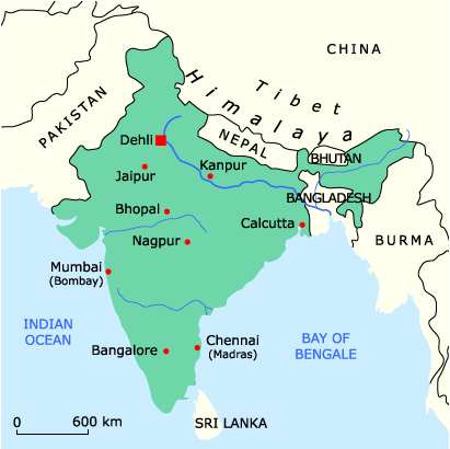
There are three main areas.
It is one of the most famous
areas of India.
It is more than 2,400 kilometres long and between 160
and 320 kilometres wide. Some of its peaks are the
highest in the world (the Everest,
the K2,etc.).
The Himalayas give birth to many rivers. The most
important are the Indus, the Ganges, the Yamuna and the
Brahmaputra.
It is the area South of the Narmada. It is bordered by two medium mountains : the Western and the Eastern Ghats. They look like huge stairs covered by forests.
It is the biggest in the world and includes the Indus and the Ganges basins. The Ganges basin is 1 million km2 wide. With the Bramaputra, it creates the largest delta in the world (140,000 kms).
From December to March, it is quite dry and the sky remains mainly clear. The temperatures depend on the latitudes but are usually above 20°C during the day. However it remains quite cold in the Himalayas (less than 15°C).
From March to May, India is at its warmest. There are almost no rains and temperatures are above 40°C inland.
The monsoon lasts from June to September. It then rains everywhere. The West coast are heavily wet while the inland and the East Coast can remain quite dry.
After the monsoon (from October to November), some tropical hurricanes can take place and wreak havoc.
Agriculture represents about 70 % of the population and accounts for 30 % of the gross domestic product. The rural density is thus very high. It is based on three major cereals:
- India is the second world producer of rice. It is grown in the wettest areas (East and West coast as well as the Ganges plain).
- It is the world's third producer of wheat. It can be found mainly in the North.
- Millet, which is associated with peanuts, are found in the driest parts (the Dekkan and the North-West areas).
Tea, coffee and heveas are mainly grown around the
Himalayas. India was the first
tea grower of the world in 1994.
It also grows sugar canes and cotton.
Cattle is very important too since its density is the
highest in the world.
India is the 4th coal
producer and produces other numerous ores
(manganese, mica, copper, etc.). The production of oil
and gas is still growing.
Iron and steel industry is particularly important as
well as the textile industry.
Évalue ce cours !

Des quiz et exercices pour mieux assimiler sa leçon
La plateforme de soutien scolaire en ligne myMaxicours propose des quiz et exercices en accompagnement de chaque fiche de cours. Les exercices permettent de vérifier si la leçon est bien comprise ou s’il reste encore des notions à revoir.

Des exercices variés pour ne pas s’ennuyer
Les exercices se déclinent sous toutes leurs formes sur myMaxicours ! Selon la matière et la classe étudiées, retrouvez des dictées, des mots à relier ou encore des phrases à compléter, mais aussi des textes à trous et bien d’autres formats !
Dans les classes de primaire, l’accent est mis sur des exercices illustrés très ludiques pour motiver les plus jeunes.

Des quiz pour une évaluation en direct
Les quiz et exercices permettent d’avoir un retour immédiat sur la bonne compréhension du cours. Une fois toutes les réponses communiquées, le résultat s’affiche à l’écran et permet à l’élève de se situer immédiatement.
myMaxicours offre des solutions efficaces de révision grâce aux fiches de cours et aux exercices associés. L’élève se rassure pour le prochain examen en testant ses connaissances au préalable.

Des vidéos et des podcasts pour apprendre différemment
Certains élèves ont une mémoire visuelle quand d’autres ont plutôt une mémoire auditive. myMaxicours s’adapte à tous les enfants et adolescents pour leur proposer un apprentissage serein et efficace.
Découvrez de nombreuses vidéos et podcasts en complément des fiches de cours et des exercices pour une année scolaire au top !

Des podcasts pour les révisions
La plateforme de soutien scolaire en ligne myMaxicours propose des podcasts de révision pour toutes les classes à examen : troisième, première et terminale.
Les ados peuvent écouter les différents cours afin de mieux les mémoriser en préparation de leurs examens. Des fiches de cours de différentes matières sont disponibles en podcasts ainsi qu’une préparation au grand oral avec de nombreux conseils pratiques.

Des vidéos de cours pour comprendre en image
Des vidéos de cours illustrent les notions principales à retenir et complètent les fiches de cours. De quoi réviser sa prochaine évaluation ou son prochain examen en toute confiance !


Fiches de cours les plus recherchées


Envie de progresser et de réussir votre année scolaire ?
Testez gratuitement pendant 24h notre plateforme de soutien scolaire !

Un espace dédié aux parents pour suivre les progrès
Tout le programme scolaire du CP à la Terminale
Des profs expérimentés disponibles à la demande par tchat, audio ou vidéo