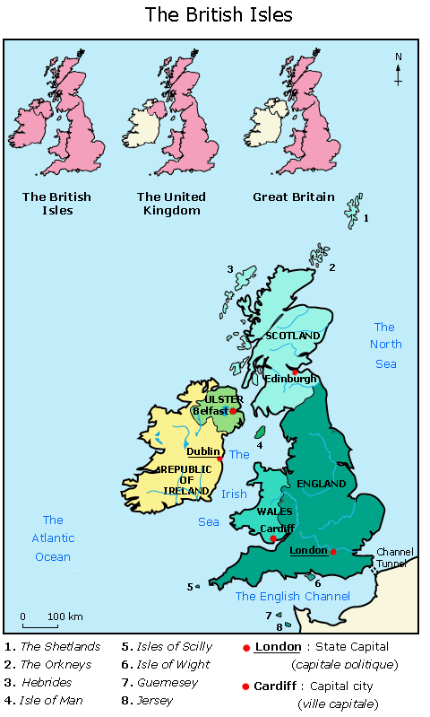
A map of the British Isles
- Fiche de cours
- Quiz et exercices
- Vidéos et podcasts
Découvrir la géographie et la composition politique des îles britanniques
- Les îles britanniques sont composées :
- du Royaume-Uni, qui comptent les pays suivants
:
- Angleterre,
- Pays de Galles,
- Ecosse,
- Irlande du Nord.
- de la République d'Irlande.
- du Royaume-Uni, qui comptent les pays suivants
:
- La Grande-Bretagne est la plus grosse île de
cette formation, sur laquelle se situent :
- l'Angleterre,
- le Pays de Galle,
- l'Ecosse.

The British Isles are composed of England, Scotland, Wales, Northern Ireland (Ulster) and the Irish Republic (Eire).
It is not to be mistaken with:
- Great Britain: Scotland, Wales and England are a geographic entity.
- The United Kingdom: England, Scotland, Wales and Northern Ireland are a political entity.
The British Isles cover 314 400 square kilometres.
More than 62 millions people live there.
It's 244 820 km2.
The climate is temperate, moderated by southwest
winds.
It's a constitutional monarchy: the
Queen is Elizabeth II. She takes the crown in
1952.
There was an estimated 59 millions people living in the
United Kingdom in 2001.
Its highest peak is Ben Nevis in Scotland (1 343 m),
the second highest is the Snowdon in Wales (1 085 m).
The United Kingdom is composed of 4 countries:
- England is 130 412 km2, its biggest city is London (7 millions inhabitants).
- Wales is 20 779 km2, its biggest city is Cardiff (315 000 inhabitants).
- Scotland is 78 133 km2, its biggest city is Edinburgh (448 900 inhabitants).
- Ulster is 13 756 km2, its biggest city is Belfast (297 300 inhabitants).
Agriculture is intensive (wheat, sugar beet, barley). The
economy is one of the strongest in Europe (heavy industry
in the Midlands, wool in Yorkshire, iron industry in
Lancashire, coal in Scotland, aeronautic in Belfast). The
United Kingdom has large coal and oil reserves.
The most visited places are the Tower of London, Windsor Castle (in Berkshire), Westminster Abbey (London), and The British museum (London).
It's 70 280 km2. The climate is temperate. The
president of the Republic is Mary
McAleese (since 1997).
3 800 000 people lives in Eire. The capital is
Dublin, with 953 000
inhabitants.
Its highest peak is Carrauntoohil (1 040 m).
The relief is composed of rugged hills, low mountains and
sea cliffs on west coast.
Eire produces turnips, barley, potatoes, and sugar beet.

Des quiz et exercices pour mieux assimiler sa leçon
La plateforme de soutien scolaire en ligne myMaxicours propose des quiz et exercices en accompagnement de chaque fiche de cours. Les exercices permettent de vérifier si la leçon est bien comprise ou s’il reste encore des notions à revoir.

Des exercices variés pour ne pas s’ennuyer
Les exercices se déclinent sous toutes leurs formes sur myMaxicours ! Selon la matière et la classe étudiées, retrouvez des dictées, des mots à relier ou encore des phrases à compléter, mais aussi des textes à trous et bien d’autres formats !
Dans les classes de primaire, l’accent est mis sur des exercices illustrés très ludiques pour motiver les plus jeunes.

Des quiz pour une évaluation en direct
Les quiz et exercices permettent d’avoir un retour immédiat sur la bonne compréhension du cours. Une fois toutes les réponses communiquées, le résultat s’affiche à l’écran et permet à l’élève de se situer immédiatement.
myMaxicours offre des solutions efficaces de révision grâce aux fiches de cours et aux exercices associés. L’élève se rassure pour le prochain examen en testant ses connaissances au préalable.

Des vidéos et des podcasts pour apprendre différemment
Certains élèves ont une mémoire visuelle quand d’autres ont plutôt une mémoire auditive. myMaxicours s’adapte à tous les enfants et adolescents pour leur proposer un apprentissage serein et efficace.
Découvrez de nombreuses vidéos et podcasts en complément des fiches de cours et des exercices pour une année scolaire au top !

Des podcasts pour les révisions
La plateforme de soutien scolaire en ligne myMaxicours propose des podcasts de révision pour toutes les classes à examen : troisième, première et terminale.
Les ados peuvent écouter les différents cours afin de mieux les mémoriser en préparation de leurs examens. Des fiches de cours de différentes matières sont disponibles en podcasts ainsi qu’une préparation au grand oral avec de nombreux conseils pratiques.

Des vidéos de cours pour comprendre en image
Des vidéos de cours illustrent les notions principales à retenir et complètent les fiches de cours. De quoi réviser sa prochaine évaluation ou son prochain examen en toute confiance !


